Whitehorse’s GIS-based, Multi-Criteria Evaluation Tool for Crosswalk Prioritization
The City of Whitehorse is working with residents to improve pedestrian infrastructure and safety. A sophisticated decision-making tool for prioritizing improvements to pedestrian and cyclist crossing locations was developed to facilitate discussions regarding community decisions, while at the same time providing a defendable, evidence-based and replicable system of outcomes.
In recent years, several planning and implementation processes were implemented to address pedestrian safety concerns. However, design inconsistencies and a reactive approach to crosswalk improvement were still predominant while lacking considerations for transportation equity and pedestrian mobility principals when evaluating and prioritizing crosswalk interventions.
Traditional network screening methods for road safety applications rely almost exclusively on collision data (frequency, rates and severity) and resident's complaints. This project aimed to expand those criteria to include equity, accessibility, pedestrian connectivity and proximity to community assets and social services. The data was integrated into a workable multi-criteria assessment framework with available municipal GIS data.
A Multi-Criteria Decision Analysis Tool
Morrison Hershfield collaborated with the City of Whitehorse to develop a consistent decision-making tool for prioritizing improvements to existing and new pedestrian and cyclist crossing locations across the City’s road network. This GIS based Multi-Criteria Decision Analysis (MCDA) approach enables stakeholders to engage in discussions regarding community decisions, while providing a defendable, evidence-based and replicable system of outcomes. The study also provided information for crossing design review best practices so that pedestrian controls are consistent with national standards.
“Our team quickly identified the significant potential in using and manipulating available Big Data to better prioritize the City’s future transportation improvements based on traditional methods plus emerging equity considerations,” notes Andres Baez, Senior Transportation Engineer.
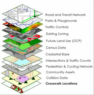
Using GIS for Analysis
 The MCDA tool was developed to evaluate 150 signalized and unsignalized crossing locations in Whitehorse, with the aim of ranking them for further investigation and capital planning purposes. The tool follows pedestrian crossing design treatment best practices, road safety and transportation equity considerations.
Geographic Information System (GIS) was instrumental in the development of the MCDA tool, serving as a geodatabase for data analysis, criteria evaluation and visualization of results. GIS was used throughout all phases of the assessment to map the data needed to accurately assess any given area. The GIS overlay geodatabase for analysis included:
- Crosswalk location and characteristics.
- Pedestrian links data (type, location, alignment, length).
- Road network information and traffic volume .
- Cycling and pedestrian networks.
- Five-year collision data.
- City-wide community points of interest (schools, recreation centres, parks, playgrounds, hospitals, etc.);
- Census socio-demographic information.
- Existing/future land uses.
- Transit bus routes/stops.
A Successful Innovation
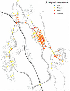 The MCDA tool helped the City prioritize crosswalk locations for future interventions based on safety, connectivity and important community mobility considerations to enhance transparency, objectivity and effectiveness in the provision of pedestrian crossing controls. The innovative strategy implemented by the team facilitated a holistic assessment of issues and the recommendation of defensible priorities for the City to include in their capital planning process. Close collaboration with City staff was instrumental to the success of this project. Working together, the City and Morrison Hershfield were able to marry GIS municipal data, transportation planning expertise and industry best practices to develop an advanced yet practical tool for improving pedestrian infrastructure and safety.
Want to know more?
If you are interested in using a Multi-Criteria Decision Analysis (MCDA) tool for prioritizing improvements to pedestrian and cyclist crossing locations or seeking more information about the tool, please contact Andres Baez, Senior Transportation Planning Engineer: Abaez@morrisonhershfield.com.